Conditions are “rapidly deteriorating along the northern Gulf coast”, the National Hurricane Center (NHC) said in a 4pm ET update as Hurricane Isaias, with sustained winds of 120mph (193kmh), closes in on land.
Forecasters at AccuWeather say landfall could occur even earlier this evening than predicted, now at around 10pm ET, as stronger steering winds pick up in the Gulf of Mexico.
“Isaias is moving toward the Gulf Coast at a much faster pace than many hurricanes we see earlier in the season,” AccuWeather’s expert meteorologist Isaac Longley said in an afternoon statement.
“Stronger steering winds are pushing the storm north, while increasing wind shear could cause it to lose some wind intensity before landfall. But that does not mean the danger is decreasing. Damaging winds could spread across a larger area, putting more communities at risk.”
Here is the latest satellite video showing Isaias closer to land:
In a Friday afternoon media briefing, Florida’s governor Ron DeSantis said he expected landfall around 11pm ET. A quicker pace reduces the time available for coastal communities to complete final preparations.
The NHC’s latest update places Isaias 90 miles (145km) south of Pensacola, Florida; and about 115 miles south south east of Mobile, Alabama.
The center of the storm is moving north at 17mph, the statement said, adding that a wind gust of 47mph was reported in Navarre Beach, Florida.
An extreme wind warning is in effect through 8:45pm CDT for several areas in Florida’s Panhandle including southeastern Escambia county, southern Santa Rosa county, southern Okaloosa county, and southwestern Walton county.
“Treat these imminent extreme winds as if a tornado was approaching and move immediately to an interior room or shelter NOW!” the Mobile office for the National Weather Service wrote to X on Friday.
The NWS called the situation “extremely dangerous” and advised area residents to stay away from windows and to seek cover under a table or another piece of sturdy furniture.
Isaias, which has begun to lash the Gulf Coast with heavy rain and powerful gusts of wind reaching up to 70mph (112km/h), is putting strain on Florida and Alabama’s energy grid.
As of Friday evening, in northwest Florida, over 110,000 customers are experiencing outages, according to PowerOutage.com. In Alabama, more than 75,000 customers lack power.
The figures mark a jump from earlier in the day when collectively over 30,000 customers did not have electricity in both states.
The Gulf coast electric cooperative, which serves about 20,000 customers in the Florida Panhandle, confirmed scattered outages in a Friday post to Facebook.
“Unfortunately, weather conditions have deteriorated to the point that, for the safety of our crews, we must temporarily suspend outage restoration efforts until conditions improve and it is safe to resume work,” the company wrote.
“We understand how frustrating it is to be without power, and we sincerely appreciate patience and understanding.”
Evacuation orders have widened across northwest Florida, which is poised to bear the brunt of the hurricane along the coast.
The mandatory notices come as officials gear up for Isais to make landfall on Friday evening.
Meanwhile, in Alabama, tourists and visitors were ordered to leave parts of Baldwin County and Mobile County on Wednesday, where getaway favorites like Orange Beach and Dauphin Island are located.
“Departing now will help reduce congestion, support emergency operations, and ensure the safety of those who may be most vulnerable during the storm,” Gulf Shores and Orange Beach officials said then in a news release.
In Mississippi, the state has issued a voluntary evacuation order for parts of Jackson county that are low-lying or otherwise flood-prone, such as areas near waterways.
Millions of residents along the Gulf coast are on watch for potential storm surge flooding. The warnings, targeting cities including Baton Rouge, New Orleans, Tampa and Miami, are in effect through Tuesday afternoon.
As a remidner, since Isais is the first Atlantic hurricane this year, the term storm surge refers to rising tide levels due to a storm. The National Weather Service issues the warning to indicate the risk of life-threatening deluges as water rapidly moves inland.
The impact may be most pronounced on Florida’s western panhandle, which is forecast to receive 6 to 9 feet of storm surge.
Hurricane Isaias’s intensity and wind speed have weakened slightly, according to the latest National Hurricane Center (NHC) advisory, although it remains a major category 3 storm.
In its 5pm ET update, the NHC recorded the cyclone’s maximum sustained winds at 115mph (185kmh), down 5mph from an update an hour previously, but still above the 111mph threshold for a major hurricane.
“Data shows that the [storm’s] structure is becoming increasingly asymmetric,” NHC hurricane specialist Robbie Berg wrote, noting that growing “deep-level” wind shear from the south west was beginning to have an effect.
Despite the slight weakening, he said, “it’s very likely that Isaias will be a gustier-than-normal hurricane when it makes landfall”.
Forecasters, and Florida’s governor Ron DeSantis, expected Isaias to come ashore somewhere along the Florida panhandle, east of Pensacola, between about 9pm and 11pm on Friday evening, as a category 3 or strong category 2 hurricane.
If Isaias makes landfall Friday night as forecast, it will be exactly two years to the day since Hurricane Milton became the last hurricane to strike the US, on 9 October, 2024, according to AccuWeather.
More than 30,000 customers have already lost power in Alabama and Florida, according to poweroutage.us, which maintains a rolling nationwide tally.
Shortly before 5pm ET, 15,698 were without electricity in Alabama, and 14,570 had lost power in Florida.
Authorities have warned of widespread and long-lasting power outages as Hurricane Isaias passes through on Friday night into Saturday.
Donald Trump has cancelled plans to head to Alabama for a big college football game on Saturday night because of Hurricane Isaias, he announced Friday on Truth Social.
The president had been scheduled to attend the game between Georgia and Alabama in Tuscaloosa, set to kick-off at 7.30pm.
On Wednesday, Trump said he would “let the hurricane decide” if he would go, in comments to reporters at the White House during a mini-press conference in which, according to this video posted to Facebook by CNN, he was unaware there was a storm brewing until members of the media told him.
In his Friday afternoon post littered with Trump’s traditionally shaky punctuation and random upper case letters, he wrote:
Based on the fact that a huge Hurricane/Storm is coming, it is important to have our wonderful First Responders, Law Enforcement, and others, focused on that Storm, and in no way be thinking about the safety, or presence, of the President of the United States, ME!
Therefore, I will miss that potentially unbelievable Game, Alabama vs. Georgia but, hopefully, the Game will go on despite the weather! I will be visiting both of those Teams at a later date.
Conditions are “rapidly deteriorating along the northern Gulf coast”, the National Hurricane Center (NHC) said in a 4pm ET update as Hurricane Isaias, with sustained winds of 120mph (193kmh), closes in on land.
Forecasters at AccuWeather say landfall could occur even earlier this evening than predicted, now at around 10pm ET, as stronger steering winds pick up in the Gulf of Mexico.
“Isaias is moving toward the Gulf Coast at a much faster pace than many hurricanes we see earlier in the season,” AccuWeather’s expert meteorologist Isaac Longley said in an afternoon statement.
“Stronger steering winds are pushing the storm north, while increasing wind shear could cause it to lose some wind intensity before landfall. But that does not mean the danger is decreasing. Damaging winds could spread across a larger area, putting more communities at risk.”
Here is the latest satellite video showing Isaias closer to land:
In a Friday afternoon media briefing, Florida’s governor Ron DeSantis said he expected landfall around 11pm ET. A quicker pace reduces the time available for coastal communities to complete final preparations.
The NHC’s latest update places Isaias 90 miles (145km) south of Pensacola, Florida; and about 115 miles south south east of Mobile, Alabama.
The center of the storm is moving north at 17mph, the statement said, adding that a wind gust of 47mph was reported in Navarre Beach, Florida.
The National Weather Service issued a tornado warning within the last hour for an area of Florida coastline around Apalachicola, about 150 miles east of Pensacola.
Forecasters have warned that tornadoes spawned in Hurricane Isaias’s outer bands could become deadly, and can form hundreds of miles from the storm’s central core.
A wide swathe from Mobile, Alabama, to beyond Florida’s panhandle remains under a tornado watch until at least 9pm ET, the NWS said, with an extension of that timeframe likely.
Isaias is forecast to make landfall east of Pensacola at about 11pm ET.
DeSantis praised the mobilization of emergency personnel, including National Guard troops, search and rescue teams, electricity workers, state troopers and others he said will help Florida recover quickly from whatever Isaias brings.
“For the next 24 to 36 hours, you know you’re going to see some nasty weather one way or another if you’re in this part of the state,” he said, adding that emergency shelters were still open for people who needed to evacuate.
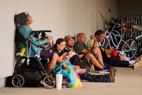
“We’ve got a massive amount of supplies and personnel ready to respond once the storm hits. Over 1,400 generators, massive amounts of gasoline that are strategically staged in different parts of the region. Food, water, all the things that we normally do are there, and they are ready to go.”
But he said, residents in affected areas should have planned to be self-sufficient, with at least 72 hours of supplies.
“Hopefully you’ve done what you need to do,” DeSantis said, adding that extended power outages were inevitable.
“The linemen [will] get in there, turn the power back on, and we get rocking and rolling, clean up debris, and get everyone back on their feet as quickly as possible.”
Ron DeSantis, Florida’s governor, said he anticipates landfall of Hurricane Isaias at about 11pm ET tonight as a major category 3 storm.
Speaking at an emergency briefing currently under way in Tallahassee, DeSantis also gave an update to the storm’s predicted track, which he said now carries the center of Isaias east of Pensacola:
It very well may make landfall as a major hurricane, so that’s a major event.
It’s something that we prepared for, but folks who are in the path of this storm should know that this is not just going to be a random tropical system. It’s going to be a strong hurricane, and it’s going to potentially do a lot of damage.
DeSantis said there was “more and more confidence” that the storm’s center would come ashore somewhere in Santa Rosa or Okaloosa counties, east of the city of Pensacola:
If it does shift to the east of Pensacola, it’s possible that the water in the bay there is actually pushed out, and you could actually have negative storm surge.
Anything to where it hits into the east of it is going to generate significant storm surge. If does come in that area around Fort Walton Beach, Santa Rosa, those areas, Destin, obviously, you’re going to have a potential surge event.
We expect to be hearing shortly from Florida’s governor Ron DeSantis in what is likely to be his final press conference before Hurricane Isaias makes landfall somewhere along the state’s panhandle later on Friday.
DeSantis, along with the governors of Alabama and Mississippi, has already declared a state of emergency for Florida, and will undoubtedly give an update on final preparations for the storm’s arrival, and resources that will be in place for rescue and recovery missions in its aftermath.
We’ll also be listening to hear if DeSantis, a Republican, has brushed up on the correct pronunciation of Isaias, a common Spanish-language name he called “weird”.
“I don’t know how to pronounce this because it’s not normal. So, you know, I’m calling it ‘Isaiah’. You guys can call it what you want,” he told reporters at a briefing on Thursday.
Some seasoned hurricane watchers have their own measures to gauge how severe a storm is likely to be. One is the arrival in town of Jim Cantore, meteorologist for the Weather Channel, whose presence is seen in some quarters as a harbinger of not very good things to come.
As with previous storms, sightings of Cantore ahead of Hurricane Isaias quickly caused a stir on social media.
His Wednesday night arrival at Pensacola airport was posted on Facebook with the unflattering caption “the Grim Reaper has reared its ugly head”, and among the more than 900 comments was one that said: “When I saw that guy on my plane, I knew nothing good was going to happen”.
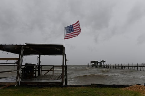
Cantore is anchoring the Weather Channel’s hurricane coverage and recorded one of his trademark segments from windswept Miramar Beach, Florida, on Friday morning, against a backdrop of rough waves.
Another indicator is the so-called Waffle House index, a kind of semi-official metric used by the Federal Emergency Management Agency (Fema) to help assess where resources are likely to be needed most.
Waffle House restaurants have developed a reputation for staying open late before a storm, or reopening quickly afterwards.
As of Friday afternoon, dozens of Waffle House locations in the Florida panhandle were closed, according to the restaurant’s website, reported by the Associated Press.
The National Hurricane Center has just published its 2pm ET advisory on Isaias’s position and intensity. The center of the storm is about 145 miles (235km) south of Pensacola, Florida, and about 125 miles south east of the mouth of the Mississippi river.
It remains a major category 3 hurricane, with maximum sustained winds of 120mph, and is moving north north east at about 16mph.
Tropical storm force conditions are already being felt along the northern Gulf coast, the update said. Landfall is expected between 8pm and 10pm ET.
“Preparations against life-threatening storm surge and devastating winds should be completed in the next couple of hours,” the update said.
While deadly storm surge and hurricane-force winds are the biggest threat to life close to the cyclone’s center, other impacts from Isaias could reach states much further away.
AccuWeather, the online forecasting service, is warning of tornadoes far from the hurricane’s core, and deep inland. While the highest risk will be near and to the east and southeast of the center of the storm, the service said, tornadoes can extend out for hundreds of miles.
This short video clip shows the outer bands of Hurricane Isaias already reaching into Georgia and the Carolinas, even while the center of the storm is still churning in the Gulf of Mexico.
“The combination of a zone of warm and humid air near the ground and a wedge of dry air at mid-levels of the atmosphere may pave the way for severe thunderstorms capable of producing tornadoes,” AccuWeather chief meteorologist Jon Porter said in a statement.
Tornado risk will be highest in Alabama, Florida and Mississippi to southeastern Alabama and southern Georgia on Friday night into Saturday as the storm makes landfall and moves inland, AccuWeather said.
Through Sunday and Sunday night, the risk will extend from central Georgia to much of South Carolina, North Carolina and southern Virginia.
Alabama’s Mobile regional airport will close in the next hour to commercial flights as Isaias gets closer, authorities announced in a social media post.
Delta, American and United airlines all operate from the airport, which said air traffic had already been disrupted by worsening weather conditions. The airport will close at 1pm CT (2pm ET).
Florida’s Pensacola international airport closed its passenger terminal at 10am CT Friday, and the smaller, regional Destin-Fort Walton Beach airport halted operations on Thursday night “until further notice”.
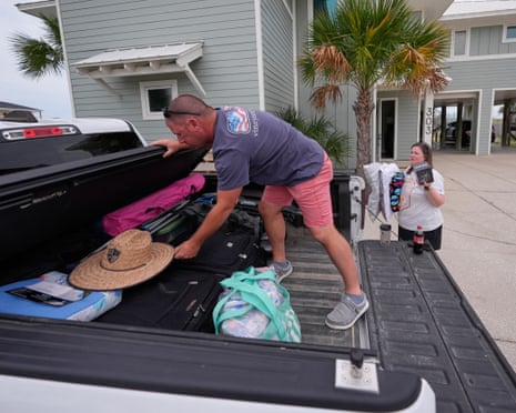
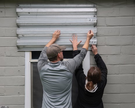
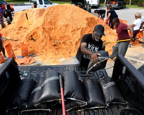
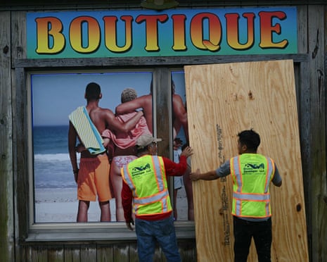
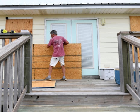
With Hurricane Isaias expected to make landfall later on Friday or early on Saturday, Gulf coast residents boarded up houses and shops and secured belongings to protect them against the coming storm. Residents in Mobile, Alabama, were picking up sandbags at a local recreation center.
These are some of the latest images from the newswires as people prepare for the hurricane:
The 11am ET update on Hurricane Isaias from the National Hurricane Center (NHC) in Miami brought unwelcome news in that predicted wind shear that had been expected to weaken the storm ahead of landfall might not materialize in time.
Isaias is currently churning in the northern Gulf of Mexico as a major category 3 hurricane with sustained wind speeds above 111mph (178kph). According to the NHC, it could still be one as it comes ashore.
A series of regional models, NHC hurricane specialist Robbie Berg wrote in the latest advisory, “all suggest that Isaias could maintain major hurricane intensity up until its landfall this evening.
“Weakening will occur after landfall, but sustained hurricane-force winds will likely occur near and along Isaias’s track up to 100 miles inland from the coast into southern Alabama, and gusts to hurricane force could extend even farther north into central Alabama.”
The Saffir-Simpson scale that grades tropical cyclones characterizes a category 3 hurricane as one in which: “Devastating damage will occur. Well-built framed homes may incur major damage or removal of roof decking and gable ends.
“Many trees will be snapped or uprooted, blocking numerous roads. Electricity and water will be unavailable for several days to weeks after the storm passes.”
Forecasters at AccuWeather are equally cautious.
“Isaias is in a race against the clock,” its expert meteorologist Tyler Roys said in a statement.
“Strong winds high in the atmosphere are expected to disrupt the hurricane before landfall, but if those winds arrive even a few hours later than expected, Isais could maintain its Category 3 strength.
“Regardless of whether it makes landfall as a Category 2 hurricane or Category 3 hurricane, communities along the Gulf Coast face a serious threat from life-threatening storm surge, damaging winds and flooding.”
Welcome to our live coverage of Hurricane Isaias, the first Atlantic hurricane of the 2026 season, which picked up power Friday morning as it turned northwards through the Gulf of Mexico.
Isaias is expected to make landfall Friday evening or early Saturday somewhere along the northern Gulf coast.
The National Oceanic and Atmospheric Administration (NOAA) is warning of life-threatening storm surge, damaging hurricane-force winds, and flooding in parts of Florida, Mississippi, and Alabama.
Emergency declarations have been issued in all three states.
The storm strengthened into a major Category 3 hurricane overnight, with sustained winds in excess of 111mph (178kph). The National Hurricane Center in Miami said Friday morning it was no longer confident that upper-level wind shear will arrive in time to weaken Isaias before landfall.
I’m Richard Luscombe in Miami, and I’ll bring you developments as they happen. Meanwhile, here’s our latest news story as coastal Gulf residents prepare for impact.
The Guardian wp:paragraph
هلدینگ کاسپین استانبول | خرید ملک در ترکیه | صرافی معتبر ایرانی در ترکیه | خرید و فروش طلا در ترکیه | مهاجرت به ترکیه | واردات و صادرات در ترکیه | نیازمندیهای ترکیه | اخبار ترکیه | اخبار جهانی | توریست ایران | خدمات توریستی در ایران | تورهای گردشگری ایران | هلدینگ اول | خدمات کاریابی و فریلنسری و شغل | مرجع اطلاعات ایران (همه چیز در ایران) | کیف پول و خدمات مالی و پرداخت یار | اخبار ایران | تابلو زنده قیمت ارز در ترکیه و استانبول | صرافی آنلاین ترکیه | قیمت طلا و نقره در ترکیه | سرمایه گذاری در ترکیه | جواهرات در ترکیه | نرخ لحظه ای ارزها در استانبول | قیمت دلار امروز در ترکیه | قیمت دلار استانبول امروز | قیمت لحظه ای دلار | اخبار روز ترکیه استانبول | اپلیکیشن ISTEX | اپلیکیشن قیمت لحظه ای دلار و یورو و لیر و ارزها در ترکیه
/wp:paragraph wp:paragraph /wp:paragraph
About the Author