Home – CBSNews.com
Add CBS News on Google
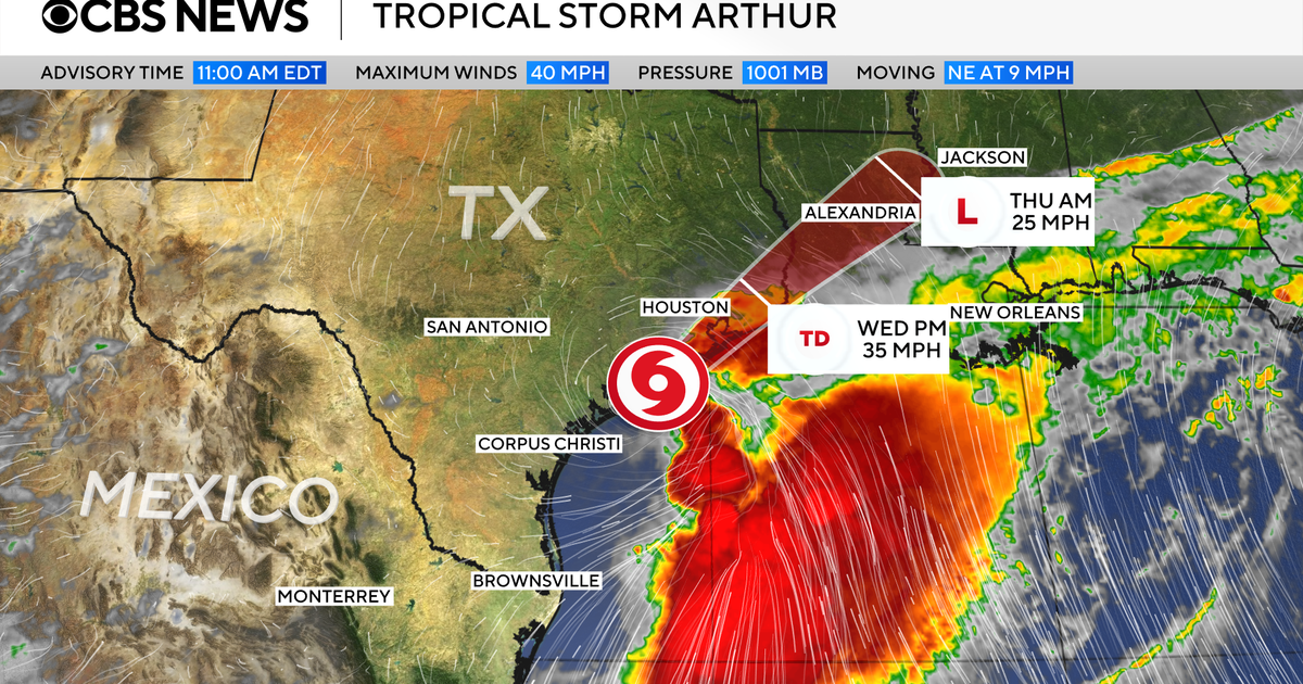
Tropical Storm Arthur formed Wednesday off the Gulf Coast of Texas, becoming the first named storm of the Atlantic hurricane season.
The storm developed near the middle of the Texas coast, less than 50 miles from Port O’Connor, according to the National Hurricane Center.
It was centered about 10 miles northwest of Galveston, Texas, and 115 miles west-southwest of Lake Charles, Texas, as of Wednesday night. It was traveling northeast with maximum sustained winds of 40 mph, just clearing the 39 mph threshold required to be considered a tropical storm. Arthur’s winds remained far below the speed necessary for a storm to be classified as a hurricane.
Forecasters predicted that Arthur would weaken and could dissipate by late Wednesday night or early Thursday, the hurricane center said. It was expected to move inland over southeastern Texas.
Regardless of Arthur’s progression, the hurricane center warned the storm would continue to bring heavy rain and flooding to a vast stretch of the southeastern United States, from Houston to Atlanta. In an advisory, forecasters said the storm was “expected to cause life-threatening flash flooding” and powerful winds in parts of the region.
Nikki Nolan/CBS News
A tropical storm warning was in place from High Island, Texas, to Morgan City, Louisiana, meaning tropical storm conditions were expected in those areas within 12 hours.
Arthur started developing earlier this week, as a tropical disturbance in the western Gulf of Mexico. It emerged and strengthened as coastal communities in the path of the storm contended with ongoing bouts of intense rain, which triggered dangerous flash flooding in multiple states.
Arthur will likely dump 5 to 10 inches of rain on sections of Texas, Louisiana, Mississippi and Alabama, along with western portions of the Florida Panhandle, the hurricane center said. Forecasters also warned that storm surge could reach 4 feet above normal levels in coastal areas that normally stay dry, depending on the timing of high tide.
“The deepest water will occur along the immediate coast near and to the east of the landfall location, where the surge will be accompanied by large and dangerous waves,” the National Hurricane Center said.
The storm was also expected to produce “life-threatening surf and rip current conditions along the northwestern Gulf Coast for the next couple of days,” it added. Some tornadoes may be possible, too.
Atlantic hurricane season runs from June 1 to Nov. 30, although tropical storm and hurricane activity usually peaks between August and October. Forecasters predicted this season will bring fewer storms than an average year, with the National Oceanic and Atmospheric Administration’s latest outlook calling for eight to 14 named storms, of which three to five might grow into hurricanes.
wp:paragraph
هلدینگ کاسپین استانبول | خرید ملک در ترکیه | صرافی معتبر ایرانی در ترکیه | خرید و فروش طلا در ترکیه | مهاجرت به ترکیه | واردات و صادرات در ترکیه | نیازمندیهای ترکیه | اخبار ترکیه | اخبار جهانی | توریست ایران | خدمات توریستی در ایران | تورهای گردشگری ایران | هلدینگ اول | خدمات کاریابی و فریلنسری و شغل | مرجع اطلاعات ایران (همه چیز در ایران) | کیف پول و خدمات مالی و پرداخت یار | اخبار ایران | تابلو زنده قیمت ارز در ترکیه و استانبول | صرافی آنلاین ترکیه | قیمت طلا و نقره در ترکیه | سرمایه گذاری در ترکیه | جواهرات در ترکیه | نرخ لحظه ای ارزها در استانبول | قیمت دلار امروز در ترکیه | قیمت دلار استانبول امروز | قیمت لحظه ای دلار | اخبار روز ترکیه استانبول | اپلیکیشن ISTEX | اپلیکیشن قیمت لحظه ای دلار و یورو و لیر و ارزها در ترکیه
/wp:paragraph wp:paragraph /wp:paragraph