Home – CBSNews.com
Add CBS News on Google
The effects of former Hurricane Polo, now a tropical storm, are expected to bring rain and flooding to the southwestern United States after the powerful storm travels across Mexico, the National Hurricane Center said Tuesday.
Polo was downgraded from a hurricane to a tropical storm Tuesday afternoon local time. As the storm’s path continues inland, more than 30 million people from Arizona to Iowa could be at risk for flash floods. Heavy rain has already flooded some roads in southern New Mexico, trapping drivers in cars until the waters receded.
Maps show Polo’s path
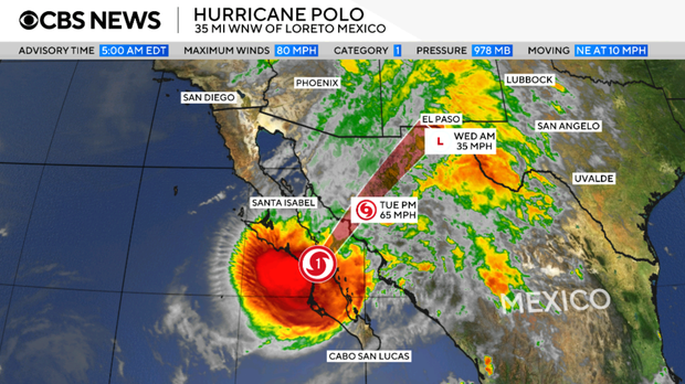
Polo made its first landfall in Mexico’s Baja California Sur as a hurricane and was moving to the northeast at about 21 miles per hour. It crossed the Gulf of California and made a second landfall in Sonora, Mexico, the hurricane center said.
CBS News
The storm is then expected to continue along its path into the southwestern United States, nearing El Paso on Wednesday morning and moving on in the northeasterly direction.
Polo had maximum sustained winds of 65 mph Tuesday, and was centered about 275 southwest of El Paso. It was forecast to have winds of about 35 mph when it reaches El Paso.
Flash flood watches
Flash flood watches are in effect from Phoenix, Arizona to Des Moines, Iowa. More than 14 million Americans are facing the risk of major flooding. Some areas may see up to two inches of rain per hour.
The National Weather Service Prediction Center said that there will be a “significant flash flood threat across the Four Corners Region eastward into the Central Plains.”
CBS News
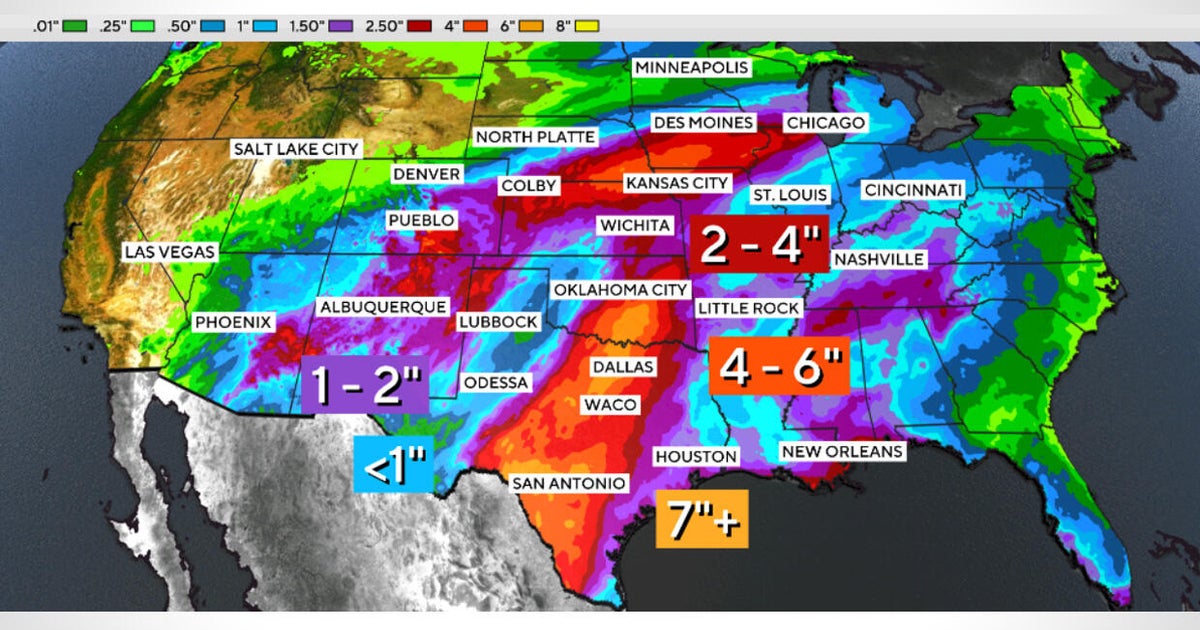
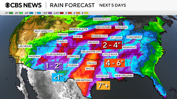
CBS News meteorologist Rob Marciano expressed a particular concern for the city of Albuquerque, New Mexico, where he said the rain may be “saturating.” The desert city is forecast to receive about 2 inches of rain.
In southern Colorado and other parts of the I-35 corridor, the rain will stretch into Wednesday. Parts of Texas, including Dallas, may see rain through Thursday. Some parts of Texas may see more than 7 inches of rain.
An active Pacific region
Before being downgraded to a tropical storm, Polo had been a powerful hurricane, at times fluctuating between Category 4 and Category 5. Early on, it underwent a process called extreme rapid intensification, which means wind speeds increased by 58 mph or more over the course of just 24 hours.
Polo’s intensification was particularly dramatic, with wind speeds jumping from 45 mph to 150 mph between Sept. 21 and Sept. 22. The NHC called called the change “truly remarkable.”
The storm’s maximum sustained winds were as high as 180 mph over the weekend, tying 2009’s Hurricane Rick as the third-strongest on record for the region. Its central pressure made it the second-strongest hurricane on record in the Eastern Pacific, only behind 2015’s Hurricane Patricia.
Warmer waters, moist air and less wind shear in the region have helped enable storm formation in the Pacific. Unusually strong El Niño conditions have also led to increased tropical cyclone activity in the region.
Another major storm, Hurricane Nolo, moved past Hawaii’s Big Island and brought heavy rain and winds to the state over the weekend.
wp:paragraph
هلدینگ کاسپین استانبول | خرید ملک در ترکیه | صرافی معتبر ایرانی در ترکیه | خرید و فروش طلا در ترکیه | مهاجرت به ترکیه | واردات و صادرات در ترکیه | نیازمندیهای ترکیه | اخبار ترکیه | اخبار جهانی | توریست ایران | خدمات توریستی در ایران | تورهای گردشگری ایران | هلدینگ اول | خدمات کاریابی و فریلنسری و شغل | مرجع اطلاعات ایران (همه چیز در ایران) | کیف پول و خدمات مالی و پرداخت یار | اخبار ایران | تابلو زنده قیمت ارز در ترکیه و استانبول | صرافی آنلاین ترکیه | قیمت طلا و نقره در ترکیه | سرمایه گذاری در ترکیه | جواهرات در ترکیه | نرخ لحظه ای ارزها در استانبول | قیمت دلار امروز در ترکیه | قیمت دلار استانبول امروز | قیمت لحظه ای دلار | اخبار روز ترکیه استانبول | اپلیکیشن ISTEX | اپلیکیشن قیمت لحظه ای دلار و یورو و لیر و ارزها در ترکیه
/wp:paragraph wp:paragraph /wp:paragraph
About the Author